
Last week, I celebrated my dad’s 90th birthday with him at his cozy one-bedroom apartment. We talked about current and past events, which led us to comparing now to then. He lives in the town he and I grew up in, so we talked a lot about the town’s scenic changes. The question “Do you remember” came up often as we talked about places of our childhoods.
I based Ridgewood on that town. It’s the place of my childhood, with stores and houses and people no longer there. But in fictional stories, they can be there again, only different. That’s what writers do when they write fiction. We take what we know and change it to make it our own. Ridgewood is my childhood town (and other locations familiar to me) made different to suit the themes and genres of my stories.
That town my dad and I grew up in has a history. It had a beginning all its own that made it unique. Its uniqueness made it grow and flourish. So, for Ridgewood to be a real fictional town, it had to have its own history. This is what I created all those years ago in high school:
In 1702, French fur hunters and trappers who traded with both the Native American Indians and the settlers migrating west along the Allegheny valley constructed a trading post in Pennsylvania called Amity. The village remained a trading post until 1747.
On March 12, 1800, the state formed Myers County from parts of Allegheny County. Frank Wood renamed Amity to Ridge Wood in 1829 after his mother’s lineage “Ridge” and his father’s lineage “Wood.”
Ridge Wood grew into a large railroad town soon after the discovery of oil in northwestern Pennsylvania in 1859. In May 1861, tracks owned by the Atlantic and Great Western Railroad intersected with those of the Sunbury and Erie Railroad and called the “Atlantic and Erie Junction.” Frank Wood owned land at the junction and sold some to the Atlantic and Great Western in October 1861. The railroad built a ticket office at the junction and named it Ridge Wood, but through a misspelling, it became Ridgewood.
The combination of railroad growth and the discovery of oil in northwestern Pennsylvania contributed greatly to Ridgewood’s development. The town went from a population of six hundred in 1861 to nine thousand in less than six months. Many surrounding forests were stripped of almost all their valuable hardwood. Mills and farms sprang up on almost every conceivable spot.
The state recognized the boomtown as a borough in 1863 and designated it as a city in 1865.
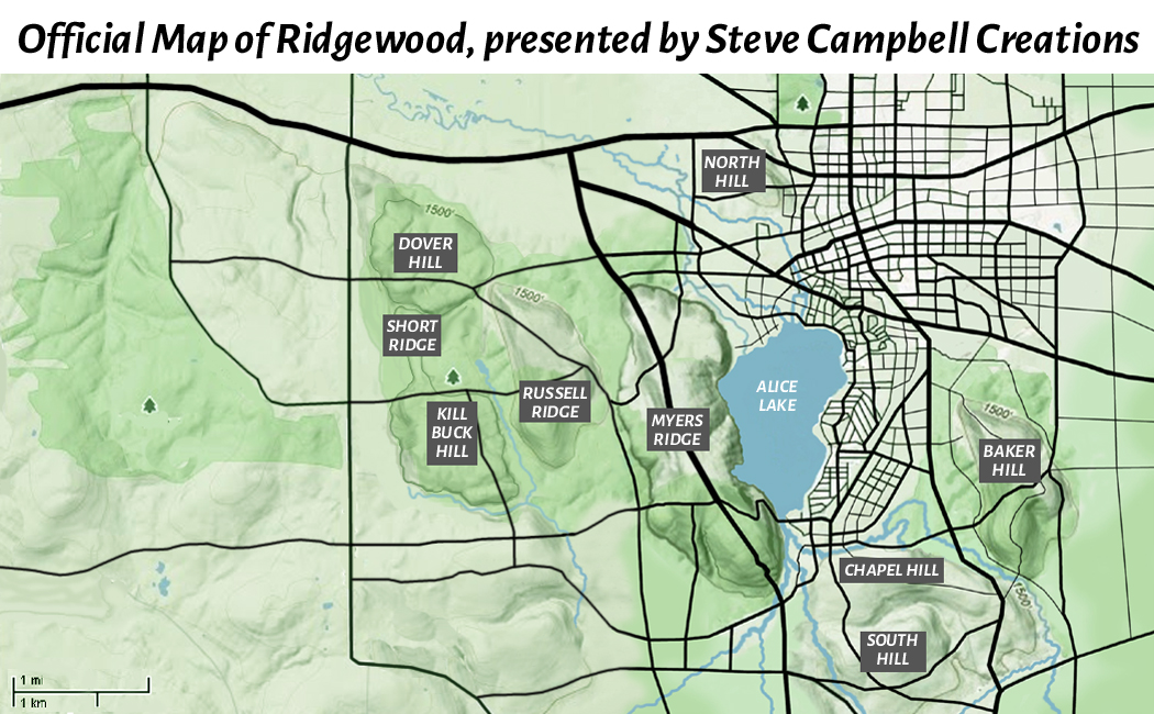
Ridgewood sits next to Alice Lake, a scenic area and community that once held the stature of being its own municipality, complete with a town hall and post office. It became a popular spot for vacationers (many from Pittsburgh) in the 1920s and became part of Ridgewood in 1957, making Ridgewood approximately two and one-half miles wide (east to west) by four and one-half miles long (north to south).
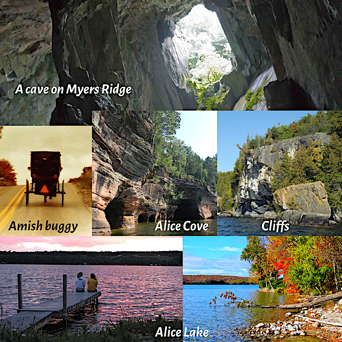
Alice Lake is a spring fed glacier-made lake one-half mile wide and a little more than one mile long, 8 acres, and with an average depth of 26 feet along a kettle bottom with holes as deep as 50+ feet. It’s surrounded by approximately 750 quaint and picturesque houses and cottages. The south side of Alice Lake comprises an Amish community, so it’s common to see horse-drawn Amish buggies traveling the lake roads no matter the time of year.
Alice Lake butts against cliffs along the eastern side of Myers Ridge. Its countryside is based on land where I live and is karst topography. Karst topography can have many sinkhole depressions sculpted in the landscape. The bedrock in Myers Ridge is composed of soluble limestone and dolostone, and chemical weathering has already occurred over thousands of years to produce large voids, known as cavities or caves. From these large voids, subsidence sinkholes and collapsing sinkholes have appeared.
With subsidence sinkholes, the fractures in the bedrock grow with time from the rainwater’s chemical reaction to the rocks. As the voids grow, groundwater flow increases, and the land slowly drops as the bedrock dissolves away.
Collapsing sinkholes happen when void spaces become too large to support the overlying soil, and an abrupt collapse occurs. Factors usually include the water table dropping which results in soil becoming very saturated and dense. Eventually the void’s roof cannot support the weight of the overlying material, and the cavity collapses instantaneously. These sinkholes can destroy entire houses and swallow portions of roads or anything else that sits above the unstable ceiling.
The cliffs are another danger plaguing old Myers Ridge. They’re on the ridge’s west side along Alice Lake and are its biggest attraction for rock climbers and cliff divers. People also hike along the cliffs and sometimes fall. Two men fell more than forty feet from the cliffs a few years ago, and the Alice Lake Park Commission has closed part of the lake and fenced it off amid fears of rocks falling from the cliff face and striking swimmers and sunbathers and people venturing to Alice Cove. The cove is a favorite place for swimmers to meet. It has several caverns, including unexplored underground caves, which are marked with No Trespassing signs and threats of fines and jailtime to keep people safe.
Despite the dangers of being on or around Myers Ridge, you can survive them when you’re an invincible character with supernatural powers.
Thanks for joining me today for this look back at the changes I made to my hometown to create a unique place and world to house my fictional characters.
Until my next post, peace and love to all.
Steve, 9/27/2024
This post “Ridgewood Places” copyright © 2024 Steven Leo Campbell at stevecampbellcreations.com – All rights reserved.


I’ve made floor plans for the houses of my fictional main characters, but I need to draw a map of the small town in which they live. It’s based on the town where I grew up in eastern Ohio.
LikeLiked by 1 person
I first used a roadmap from my parents’ glovebox in the car and traced areas onto paper, then altered them to my liking for Ridgewood. Then, when I returned to writing books about Ridgewood again (about 20 years ago), I used Google Maps for the same thing and made a new map for Ridgewood and Myers Ridge. That map shows topography, which helps when I’m trying to recall how hilly an area is. I also photograph local areas and keep them in a notebook with my maps. It makes it easier to step into my characters’ shoes when I’m writing about them interacting outdoors. I also keep drawings, floor plans and photos of important houses and buildings in my notebook, since Ridgewood and some of its characters have become a series of stories.
LikeLike